Northern Scotland
After we left Lybster, we made our way to John O'Groats. As I mentioned, John O'Groats is one of the northernmost points in Scotland. Of course, it also holds that spot for the United Kingdom. It's not the furthest north, though. That distinction belongs to nearby Dunnet Head. Ferries run from John O'Groats to the nearby Orkney Islands.


 A tiny hint of blue peeking out from behind the clouds. And the John O'Groats sign post.

 We were only 3,230 miles from New York!
After our visit to John O'Groats, we headed west. Steve wanted to see an old nuclear facility that was in the area, and then we would take a different route south.
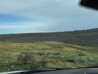
The landscape in this part of Scotland is markedly different than the glens around Inverness. Here it is rolling, grassy pastureland dotted with isolated farms.
 We saw a number of these walled cemeteries and churchyards. From a distance, they look like chess pieces.

 We drove through Thurso, which is the area's largest town with nearly 8,000 people. I snapped a pic of this lovely church as we sat at a red light.
 Scabster is a port that lies a couple of miles west of Thurso. It's a deep-water port. As you can see, the wind was kicking up the water again at this point. This ship was not moving, so we assume it was seeking safe harbor from the gale-force winds.

 The Dounreay Nuclear Facility. The site was commissioned in 1955 and was home to two fast breeder reactors. One of these was the first to provide energy for the public in Great Britain. There was also a test material reactor on the site. It was decommissioned in 1998. The reprocessing of plutonium and uranium continued through 2001, and fuel fabrication continued through 2004. The decommissioning and clean-up efforts are expected to continue until at least 2025, but the area will not be safe for redevelopment until at least 2060. The sphere is one of the fast breeder reactors.
 After our nuclear facility drive-by, we headed south on a B road through some very remote land. Roads in the UK are designated by a letter. M is a motorway, so it's very much like an interstate in the U.S. An A road is a main thoroughfare. It's at least two lanes and is fairly well maintained. A B road is one that's not regularly maintained, often runs through more remote areas, and can be as small as one lane.
 We're driving along, seeing little more than some sheep and fencing when, bam, there's a cemetery.
 We were on a single-track road that featured wide spots called passing places. We were amused that someone posted a "Like Us on Facebook" sticker on the passing place sign. We think the sticker actually refers to some political group, but we prefer our original story.
 Apparently, we were in Clan MacKay Country. A tip of the tam to any members of Clan MacKay out there. Your homeland is ruggedly beautiful.
 A photo of the loch that was featured in the video on my Blowin' a Gale post.

 Lest you think the countryside was unmarred, a shot of a deforested hill. This isn't just pastureland out here, it's also tree farms and I guess it was harvest time.
 It was a very large area of harvest. I'm surprised they didn't have the trees staggered more, so there was still tree growth in the area. I'm no farmer, so I imagine there's a good reason why they do it this way up here.
 This is a monument atop a mountain. You see this a lot in Scotland. You'll be driving along and notice something on the hill or mountain top. A quick Google search told me this was a monument to the first Duke of Sutherland atop Ben Bhraggie. Ben is Gaelic for mountain. So it's Mount Bhraggie in English, I guess. The Duke was infamous for his role in the Highland Clearances, which was the result of the Jacobite Rebellion and Battle of Culloden in 1746. Fearing continued uprisings by the Scottish clans to get a Stewart king back on the throne, Great Britain made tartans illegal, dismantled the clans, and forced the Highlanders from their land. That's one reason we have so many Scots living in Canada and the U.S. They fled Scotland rather than live suppressed by the government.
The monument dates to the 19th century, and there are some people who feel it should be removed. Why honor a man who helped destroy the Scottish way of life? They remind me of the people who are offended by the Confederate flag and seek to have it removed in the U.S. But it was decided that the Sutherland monument should remain as a reminder of the atrocity, so something similar doesn't happen again. Food for thought for those who are hell bent on wiping the Confederate flag from existence - even on historic buildings and monuments.

 Scottish weather is ever changeable. You can have sun and wind and rain all within a single morning. As we neared Inverness, the sun beamed out from behind the gray clouds in welcome. It was a pretty sight.
 And then, we received a big, bright rainbow. It stayed with us, occasionally fading out only to get bright again, for a good ten minutes. It was a very nice welcome home after a fun day of exploring some of Scotland's north.

We aren't quite to John O'Groats yet, but we can see some of the Orkney Islands in the distance. I think there are about seventy islands in the Orkney archipelago. A visit to the Orkneys is high on my bucket list, and something I hope we get to do soon.

Here is the harbor of John O'Groats.

Here's a bit of a zoom-in on the harbor entrance. It's still quite windy, but the direction has shifted so the North Sea here isn't as tumultuous. Still, it's choppy and you can see the difference between the water within the harbor and that without.


Once the John O'Groats Hotel, this lovely Victorian building on the front edge was left to ruin. Then about six years ago, some enterprising individuals decided to refurbish the building. It is now the Inn at John O'Groats. The colorful buildings alongside the hotel are an extension of the hotel. They are Nordic-inspired timber clad buildings that tip their hat to the rich history of this part of Scotland.

After our visit to John O'Groats, we headed west. Steve wanted to see an old nuclear facility that was in the area, and then we would take a different route south.
The landscape in this part of Scotland is markedly different than the glens around Inverness. Here it is rolling, grassy pastureland dotted with isolated farms.


One of the Orkney islands in the distance. I liked the mix of stone wall and cliffs. I also liked the water crashing against the island's shore. What I don't like is the poor quality of the photo.


Another zoomed-in shot, hence the poorer picture quality.


A shot of the white caps on the same loch.


The monument dates to the 19th century, and there are some people who feel it should be removed. Why honor a man who helped destroy the Scottish way of life? They remind me of the people who are offended by the Confederate flag and seek to have it removed in the U.S. But it was decided that the Sutherland monument should remain as a reminder of the atrocity, so something similar doesn't happen again. Food for thought for those who are hell bent on wiping the Confederate flag from existence - even on historic buildings and monuments.


Comments
Post a Comment