Cabo Rojo
We took a trip down to The Cabo Rojo National Wildlife Refuge, which is located in the southeast corner of the island. Some claim the region's name, which directly translates to Cape Red, comes from the red-colored hypersalinated lagoons. Others say it stems from the color of the limestone cliffs. The Refuges features a subtropical dry forest, a lighthouse, and the salt flats.
We followed a bumpy dirt road for a mile or two and came to a dead end in a parking "lot." A path meandered through the dry forest toward the lighthouse.
Unlike a desert, which tends to get minimal rain fall, a dry forest can receive a lot of precipitation. But it experiences long dry spells, often lasting months, that dictate the type of plant life that call it home. I saw a lot of coarse, leggy shrubs and cacti, like this beauty.
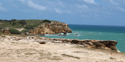
A view of the limestone cliffs towering over the coastline.
Faro Los Morillos de Cabo Rojo was built in 1881. It was electrified and fully automated in 1967.
After we toured the lighthouse, we took a stroll along the cliff's edge. Steve made me nervous because he kept stepping close to the edge.
The cliffs were Sunbathing Central for a number of large iguanas. Like this fellow.
And this guy.
Some impressive rock formations.
Can you spot the iguana? He thought he was so clever with his camouflage.
And he wasn't pleased that we spotted him.
It was a truly beautiful scene between the light terra cotta color of the cliffs
and the turquoise water of the Caribbean Sea.
Some more stately cacti.
El Puente Natural, or Natural Bridge.
Another shot of the arch.
After we finished our walk, we returned to our car and headed back the way we came. This took us through the salt flats, or Las Salinas de Cabo Rojo. The salt flats are divided into two lagoons, Fratermidad and Candelaria. The lagoons are slightly sloped, so when the tide goes back out, water is left behind. The lagoons' water becomes hypersalinated because it evaporates quicker than it does in the sea.
Salt production was practiced by the Aruaco Indians as far back at 700 B.C. Spanish explorer Juan Ponce de Leon, of St. Augustine fame, visited the island in 1508. He ordered the start of commercial salt extraction using the Taino Indians as slaves. This makes salt production the first industry in Puerto Rico and one of the oldest in the Americas.
The tide was out, but this is one of the lagoons.
I first thought the white stuff was mounds of salt.
But it turned out to be foam. Here's a big blob of it blowing in the wind.
A pile of salt.
See how the lagoon looks red? From what I've read, the color comes from the large population of brine shrimp that reside in the hypersalinated water.
These are the crystallizers. Water is pumped into it from the lagoon and allowed to evaporate. As it does so, the salt settles at the bottom. More water is added over several months. Then the water is pumped back out and the salt is scraped from the bottom.
The salt produced here is used for non-food purposes.
A shot that shows both the lagoon and the crystallizers.
Another shot of the lagoon from a different vantage point as we made our way out of the park.
More foam
I took this final shot before we made our way back north.


Comments
Post a Comment